Sell 3D without learning the software
- You fly the site, we turn the photos into a 3D model and maps
- Your client gets a web link with your logo they can spin, measure and share
- A fixed price per job, so you know your margin before you quote

[ White-label drone photogrammetry ]
Send your drone photos. Get back a checked 3D model, orthophoto, point cloud and a viewer link with your logo, usually within 48 hours. Pay per job.
Two kinds of teams send us work. Both keep their name on the result.
Under a minute, from your photos to a link your client can measure on.
01 / UploadFly the site and drag your photos into the page. Every photo is the ground seen from a known angle.
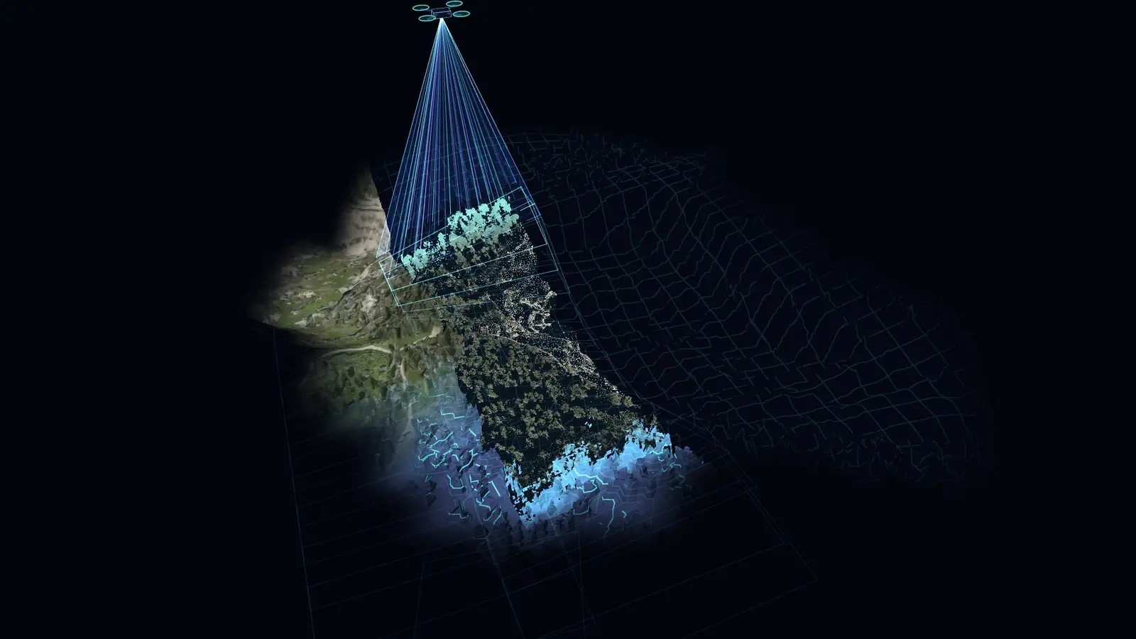
Where thousands of them cross, we find each point in 3D. A quarry like this one comes out as millions of measured points.
02 / BuildOur own render farm joins the points into a solid surface while you sleep.
03 / CheckThe photos are painted back onto the surface. Then someone checks holes, texture, alignment and the error at each of your control points.
This quarry face is 153 ft from toe to crest. The section across the benches runs 837 ft. Your client clicks, the model answers.
Pick a point and the model works out what is in view from eye level. Green can be seen, red is hidden by the terrain.
04 / DeliverA viewer link and files with your name on them. Your client only ever sees you.
This is the viewer your client would get, with a real model we processed: an open-pit quarry. Spin it, measure a slope, work out a stockpile volume.
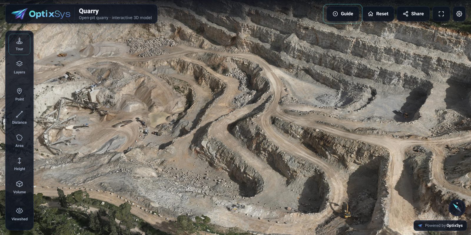 [ Live viewer ] Open-pit quarry
Open the 3D demo
[ Live viewer ] Open-pit quarry
Open the 3D demo
Pick what your client needs. Everything comes in your coordinate system, ready for CAD and GIS.
Your model online with your logo. Spin, measure distance, area, height and volume. Nothing to install.
Branded link · 90 days freeA solid model with the photos painted on. Close enough to count the units on a roof.
OBJ · FBX · 3D TilesOne huge, flat photo of the whole site, sharp enough to spot a drain cover.
GeoTIFF · true orthoMillions of measured dots. Good for volumes and surface work.
LAS · LAZA map where color means height, for slopes, drainage and earthworks.
DSM · DTM · GeoTIFFA 3D photo you can walk around in. For showing a site, not for measuring.
Ask usPay per job. No software subscription, no seats, nothing to pay in a quiet month. The upload page shows your price before you send.
| Job size | Photos | Price | Includes |
|---|---|---|---|
| Small | up to 500 | $149 | Viewer link, 3D mesh, orthophoto |
| Medium | 501 to 1,500 | $349 | Same, plus point cloud |
| Large | 1,501 to 4,000* | $749 | Same, plus elevation model |
| Bigger | over 4,000 | Quote | Same day quote |
*Over 1,500 photos, email hello@optix-sys.com and we set up the upload for you. Every job includes 90 days of viewer hosting.
| Item | Price |
|---|---|
| Processing with checkpoint accuracy report | $8 / GP |
| Minimum per job | $150 |
| Contours or cleaned ground surface | +$1.50 / GP |
You get the files and the checkpoint report. A branded viewer link is on a hosting plan. Gigapixels = photos × camera megapixels ÷ 1,000. 1,240 photos from a 45 MP camera is 55.8 GP, about $446.
| Plan | Live models | Price | Includes |
|---|---|---|---|
| Solo | up to 3 | $29 / month | Your logo on the viewer and reports, a neutral link |
| Studio | up to 15 | $79 / month | Same, on your own domain, with password links and volume reports |
| Fleet | up to 75 | $199 / month | Same, for several brands |
Every processing job includes 90 days of hosting. Yearly billing gets 2 months free. Already process your own data? Bring your own model: the first one is hosted free for 30 days.
We're opening 10 founder spots. Send one real job, we process it free, and you get the model, the files and your own viewer link. In return we may show the result on our site, and you tell us in five short written answers how it compared. Survey firm? Ask for a private blind benchmark of a job you have already delivered.
No. Files, reports and the viewer carry your company name and logo, and the file metadata is cleaned so nothing points back to us.
Most jobs are back within 24 to 48 hours of a complete upload. Bigger jobs get a delivery date before we start.
Your photos as JPG or TIFF, and if you have them, your ground control points as a CSV or TXT file with the coordinate system named. You upload them straight in the page.
Photos times camera megapixels, divided by 1,000. For example 500 photos from a 20 MP camera is 10 gigapixels. The upload page counts it for you before you send anything.
Your photos are used only for your job and processed on our own machines outside the United States, not a public cloud. We sign your NDA on request and delete your photos within 30 days of delivery, sooner if you ask. Read the data policy.
You get an invoice with the delivery. The viewer link works right away, and the download link opens once the invoice is paid.
Yes. Send us your finished model as 3D Tiles, OBJ, LAS or LAZ, or GeoTIFF and we put it in the viewer with your logo, on a hosting plan. The first one is free for 30 days. Request it here.